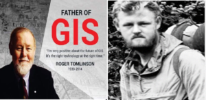
Father of GIS: Roger Tomlinson

Roger Tomlinson is widely acknowledged as the “Father of GIS” (Geographic Information Systems), a revolutionary figure whose contributions transformed the world of spatial analysis and geographic data management. His pioneering work in the 1960s laid the foundation for the modern GIS systems we rely on today.
The Birth of GIS
In the early 1960s, while working for the Canadian government, Roger Tomlinson recognized the limitations of traditional methods for handling geographic data. At that time, maps and spatial information were manually handled, making large-scale geographic analysis extremely difficult. Tomlinson envisioned a computerized system capable of analyzing and displaying complex geographic data, leading to the creation of the Canada Geographic Information System (CGIS)—the first computerized GIS.
This system allowed Canada to manage its vast land resources efficiently by automating the mapping process and facilitating the analysis of land use, agricultural productivity, and natural resources. It was a game-changing approach that set the stage for modern-day geographic analysis tools.
Key Innovations and Contributions
-
Computerization of Spatial Data: Tomlinson’s vision to digitize geographic data allowed for the automation of data processing, turning what was once an arduous manual task into a streamlined, efficient system.
-
Layered Mapping Approach: One of his critical contributions was the development of a layered approach to mapping. This technique enabled the separation of different types of data (e.g., soil types, land use, hydrology) into distinct layers that could be analyzed independently or together for a more comprehensive understanding.
-
GIS in Policy and Decision-Making: Through CGIS, Tomlinson demonstrated how GIS could be a powerful tool for decision-makers in urban planning, land management, environmental conservation, and transportation, allowing for data-driven policies and development.
-
International Influence: The influence of Tomlinson’s work extended far beyond Canada. His methods were adopted worldwide, and GIS technology became instrumental in sectors such as disaster management, natural resource management, military operations, and commercial business intelligence.
The Evolution of GIS and Tomlinson’s Legacy
Tomlinson’s work was a major catalyst in the rapid evolution of GIS technology. Today, GIS has become an indispensable tool for governments, businesses, scientists, and researchers across the globe. It plays a critical role in fields ranging from urban planning and environmental monitoring to logistics and market analysis.
Roger Tomlinson’s contributions to GIS earned him numerous accolades throughout his life, including the prestigious Order of Canada and induction into the GIS Hall of Fame. He is also remembered for his extensive writing and advocacy for the use of GIS technology to solve real-world problems.
Impact on Modern GIS
The GIS technologies we use today—whether for tracking climate change, managing city infrastructures, or planning new developments—owe their existence to Roger Tomlinson’s groundbreaking ideas. From simple mapping applications on smartphones to complex spatial analysis tools used by professionals, Tomlinson’s work continues to shape the way we interact with and understand our world.
His legacy lives on as GIS continues to evolve, driving smarter decision-making and offering solutions to global challenges.


Hi, this is a comment.
To get started with moderating, editing, and deleting comments, please visit the Comments screen in the dashboard.
Commenter avatars come from Gravatar.